What is a LiDAR Drone and How It Enhances Mapping & Spatial Awareness
What is a LiDAR drone?
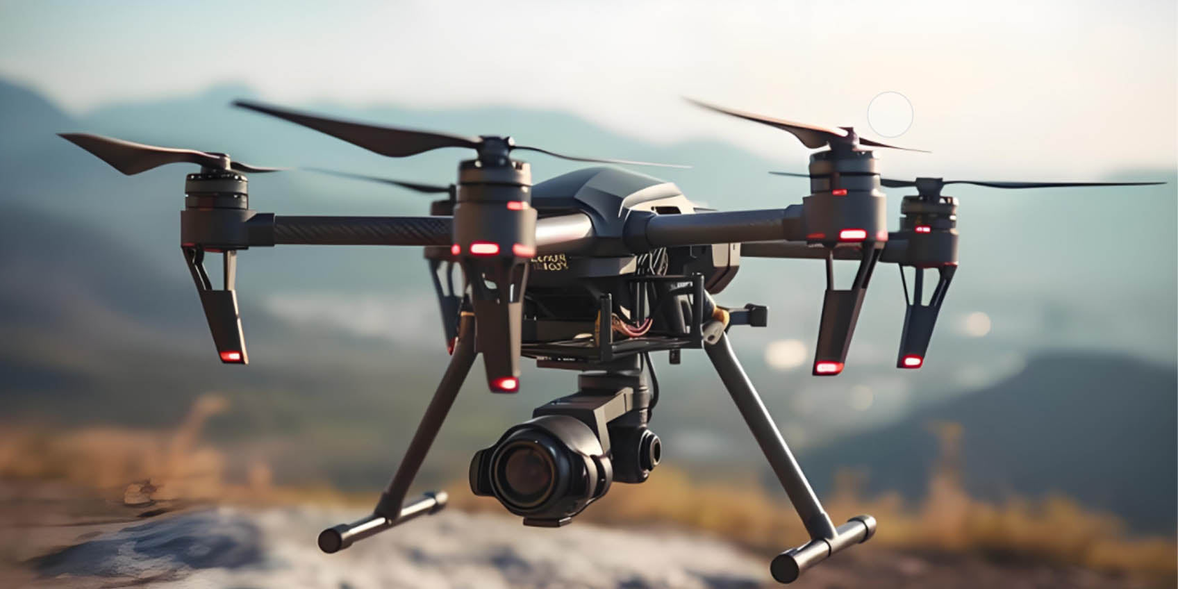
A LiDAR drone is an advanced unmanned aerial vehicle (UAV) equipped with LiDAR (Light Detection and Ranging) technology, capable of creating highly accurate 3D maps of terrain and objects. By emitting laser pulses and measuring the time it takes for the pulses to return after hitting an object, LiDAR drones provide precise 3D point cloud data that can be used for a wide range of applications, including terrain mapping, forestry management, agricultural monitoring, archaeological surveys, and urban modeling.
LiDAR drones stand out for their ability to gather accurate surface data in challenging conditions, including dense forests, mountains, and urban areas, where traditional mapping techniques often fall short. The latest advancements in LiDAR technology have made these drones indispensable tools in industries such as geographic information systems (GIS), construction, environmental monitoring, and urban planning.
However, as the demand for even greater accuracy grows, LiDAR drones face challenges in complex environments, such as highly urbanized regions or dense vegetation. The introduction of Time-of-Flight (ToF) technology has revolutionized LiDAR drones, improving their precision and the overall quality of collected data.
1. LiDAR Drones: Revolutionizing Mapping and Spatial Data Collection
LiDAR drones utilize laser beams to scan surfaces and measure distances to create high-resolution 3D data. These systems are widely used for applications like terrain mapping, building modeling, and environmental monitoring. Unlike traditional 2D mapping methods, LiDAR technology provides spatial data that captures the true topography of landscapes, making it ideal for creating accurate maps of forests, mountains, rivers, and other hard-to-reach areas. Despite its high precision, traditional LiDAR systems can encounter limitations when operating in environments with poor visibility or complex structures, where precise depth and distance measurements are essential. This is where Time-of-Flight (ToF) technology comes into play.
2. Time-of-Flight (ToF) Technology: Enhancing Depth Accuracy and Data Precision
Time-of-Flight (ToF) technology calculates the distance between an object and the sensor by measuring the time it takes for a light pulse to travel to the object and return to the sensor. This method significantly improves the precision of depth measurements in challenging environments where traditional LiDAR systems may face obstacles such as occlusions or multiple reflections. By integrating ToF technology into LiDAR drones, it becomes possible to achieve faster, more accurate distance measurements, enabling the generation of high-quality 3D point clouds during real-time flight.
The integration of ToF technology into LiDAR drones not only enhances the precision of spatial data collection but also allows for better mapping of complex terrains such as dense forests, urban environments, and mountainous regions. This combination of technologies improves data accuracy, reduces errors caused by environmental factors, and supports more comprehensive analysis across various industries.

3. The Synergy of LiDAR Drones and ToF Technology: A New Era of Mapping
LiDAR drones equipped with ToF sensors offer several key advantages in spatial data collection and modeling:
- Precise 3D Modeling and Mapping
In applications like terrain mapping or building modeling, LiDAR drones integrated with ToF technology can generate highly accurate 3D reconstructions. Traditional LiDAR systems are limited in capturing full 3D structures, especially in complex environments such as mountains, valleys, and urban areas. ToF technology enhances LiDAR's capabilities by providing depth data that fills in gaps, producing comprehensive 3D models that help professionals in construction, urban planning, and environmental research make more informed decisions.
- Improved Accuracy in Complex Environments
Urban and forested areas are often challenging for traditional LiDAR systems, as they may encounter measurement errors due to occlusions, reflections, or varying light conditions. By incorporating ToF technology, LiDAR drones can better handle these challenges. ToF sensors improve depth perception, making them highly effective for tasks like tree canopy scanning, building façade inspection, and terrain analysis in difficult conditions.
- Real-Time Dynamic Monitoring
In dynamic environments, such as post-disaster areas or ongoing construction sites, LiDAR drones integrated with ToF technology can offer real-time monitoring and 3D modeling. In disaster scenarios like forest fires or earthquakes, LiDAR drones with ToF sensors can quickly assess damage, track changes in terrain, and provide real-time data to emergency responders for better decision-making.
- Enhanced Data Analysis and Decision Support
By combining the high-precision data from LiDAR sensors with the depth data provided by ToF sensors, LiDAR drones generate multi-dimensional datasets that enhance data analysis and decision-making. Industries such as construction, urban planning, and environmental monitoring benefit from this combination, which provides a deeper understanding of spatial features, helping to optimize designs, predict risks, and plan better resource allocations.

4. Key Applications of LiDAR Drones with ToF Technology
- Urban Planning and Smart Cities
In urban planning and smart city development, LiDAR drones equipped with ToF technology offer accurate 3D models of cities, capturing data for better infrastructure planning, traffic flow analysis, and construction projects. This allows for the optimization of urban design, making cities more efficient, sustainable, and livable.
- Agriculture and Forestry Management
LiDAR drones with ToF sensors are increasingly used in agriculture and forest management. The integration of ToF technology allows agricultural experts and environmental scientists to monitor crop health, soil conditions, and forest resources with high precision. LiDAR drones can capture detailed 3D maps of agricultural landscapes and forest canopies, enabling precision agriculture and supporting sustainable forestry practices.
- Disaster Response and Emergency Management
After natural disasters like earthquakes, floods, or wildfires, LiDAR drones equipped with ToF sensors can quickly assess the extent of damage and track terrain changes. This technology supports disaster recovery, aiding in search and rescue operations and helping planners make informed decisions regarding rebuilding efforts and resource allocation.
5. The Future of LiDAR Drones with ToF Technology
As ToF technology continues to evolve, its integration with LiDAR drones will play a pivotal role in further enhancing mapping precision and data analysis capabilities. Future developments in ToF sensors are expected to improve depth measurement speed, reduce data processing times, and support even more complex environments. The continued growth of LiDAR drones with ToF technology will impact a wide range of industries, from geospatial surveying to environmental monitoring, enabling faster, more accurate data collection for a variety of applications.
Conclusion
The combination of LiDAR drones and Time-of-Flight (ToF) technology represents a breakthrough in precision mapping and spatial data collection. By enhancing depth perception, improving accuracy, and providing real-time 3D modeling, LiDAR drones with ToF sensors are driving advancements in a variety of fields, including urban planning, agriculture, disaster management, and environmental monitoring. As both LiDAR and ToF technology continue to advance, LiDAR drones will become even more indispensable for scientific research, infrastructure development, and environmental protection.
IHawk Structured Light Camera P100R 8.0M 1000x Polarization Extinction Ratio

After-sales Service: Our professional technical support team specializes in TOF camera technology and is always ready to assist you. If you encounter any issues during the usage of your product after purchase or have any questions about TOF technology, feel free to contact us at any time. We are committed to providing high-quality after-sales service to ensure a smooth and worry-free user experience, allowing you to feel confident and satisfied both with your purchase and during product use.
-
Posted in
P100R


Please upload banner from store admin blog pages